Showing posts with label Hiking. Show all posts

Thursday, February 7, 2019

Mt. Kōbō

A couple of weeks ago, I went hiking Mount Kōbō (弘法山 Kōbō-yama). Mount Kōbō is an easy day trip from Tokyo or Kanagawa with good access through the Odakyu Odawara line. This time I got off at Hadano station, climbed Mount Kōbō and then went walking towards Tsurumakionsen station where I had a relaxing thermal bath (onsen).


I suggest doing this hike in Winter when the air is clean and you have greater chances to see Mt. Fuji and the surrounding areas.


Near the mountain, there is a nice farm with sheeps grazing and waiting for you to give them some food. Their hairy body is really warm.

Tuesday, January 1, 2019

Edinburgh

In October 2018, I had the chance to attend the Automated Testing Summit and the Embedded Linux Conference in Edinburgh thanks to a sponsorship by the Linux Foundation. I spent most of my time working, attending meetings and discussing projects.


I used the little free time I had to explore the streets of Edinburgh. I was impressed by the city's architecture, and I loved the cobblestone paths and old-style buildings.


In particular, the Edinburgh castle, which is on top of a hill in the middle of the city, was astonishing. The Linux foundation organised a sweet party inside the castle, and even a better one in the National Museum of Scotland, another must-see.


After my hiking trips in Snowdonia and the Black Mountains in Wales, as well as my trip to the Lake District in North West England, I had always wanted to hike in Scotland. I didn't have time for a long route, but luckily Edinburgh has a hill called Arthur's Seat within walking distance.

Sunday, October 14, 2018

Climbing Mt. Ryoukamisan

I recently climbed Ryoukamisan (両神山, yamap, yamareco, yamakei)with some friends. Ryoukamisan is a mountain located in Saitama, near the Chichibu district. It is part of the 100 famous Japanese mountains.


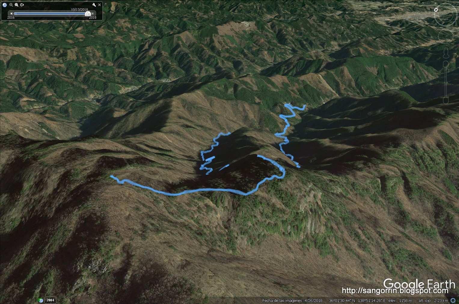
We used the the Hinataooya (日向大谷) route to get to the top of Ryoukamisan and then went back using the Nanatakizawa (七滝沢) route. Here you can download my GPS log. You can also get information about similar trips from here, here and here.


With its 1723m I would say that Ryoukamisan requires a bit of hiking experience. There are quite a few steep areas that will require you to use the chains anchored to nearby rocks. When we arrived at the top everything was cloudy. For that reason, I can't tell you if the views are good or not.


Perhaps the most interesting part of this mountain is its Shinto shrine and its relation with various Shinto deities.

Saturday, November 12, 2016

Nishizawa valley hike

I joined a meetup in August and hiked the Nishizawa valley (西沢渓谷 - Nishizawa Keikoku) which is famous for its 7 waterfalls. You can find some Japanese leaflets scanned here and here.


We met at 8:15 AM at Enzan station (JR中央本線 塩山駅) and took a bus (山梨交通) towards the bus stop 西沢渓谷入口バス停 from where we started the hike. You can see my GPS log on Google Earth for a detailed description of the route. If you want to take your own I suggest using the "Easy GPS logger" application on your smartphone. It produces a .gpx file that you can read from Google Earth.


The hike was really pleasant. Most of the route goes through a forest along a river with wonderful waterfalls. Definitely a nice mountain to try in Summer.


You'll also have the chance to cross a hanging bridge. Nothing to be scared of!. After the hike, we went to a Japanese hot spring (onsen) for a relaxing bath. Finally, I had some grapes from this region (Yamanashi prefecture) and went back home by train.

Sunday, June 19, 2016

Kamakura Sanzagaike: easy hiking trail

Kamakura was one of the first places I visited in Japan. Since then I have been several times in Kamakura, including last month when I walked the Nagoe kiredooshi pass.


Today I walked another nice trail that started near the Sanzagaike forest park (散在が池森林公園). Here are the details of the route. Go to Oofuna's JR station (大船駅) and take the bus towards Kamakura lake (鎌倉湖畔ゆき) at platform 5. Get off at the Imaizumi fudou (今泉不動) bus stop. Then, follow my GPS log (use Google earth to see the log in context) which will eventually lead you to an Italian restaurant not too far from JR Kamakura station (sorry, I didn't log the last segment but you can guess it from the map), the final destination.


Perhaps the main attraction of the route, especially if you travel in June, is the wide diversity of flowers you will see. Lillies (ユリ), Magnolias, and particularly Hortensias (アジサイ) are really abundant and popular.


There are also lots of harmless little animals to see such as beetles or lizards; and a wide variety of birds singing all the time. If you live in Tokyo this is a nice one-day trip for escaping from the daily routine.

Tuesday, May 3, 2016

The Nagoe Kiridooshi pass

A few days ago I joined a beautiful walk between the cities of Kamakura (鎌倉市) and Zushi (逗子市). The route follows ancient paths with man-made carved cliffs (大切岸 ookirigishi) and passageways (切通 kiridooshi) that used to protect the Kamakura shogunate. In particular, the route passes by the Nagoe-kiridoshi (名越切通), one of the seven major passageways that still remains close to its original form. Another interesting spot is the so-called Mandara-dou Yagura-gun (まんだら堂やぐら群), a group of cave-tombs carved into a clif.


Even if you are not interested in its historical value, the route has a lot more to offer. The beauty of its paths, the variety of trees and the smell of the Japanese wisteria flowers (beginning of May) are all worth the walk.


I have prepared a file containing the route I walked: nagoe-kiridoshi-pass.kmz. The file can be opened in Google earth or converted to your favourite GPS file format. The route starts and ends in Kamakura station. First, get on any of the following buses (you can walk instead): JR bus (platform 5) or Keihin buses no. 23, 24 and 36. Make sure your bus stops at Jōmyō-ji (浄明寺), the bus stop where you want to get off. Near the bus stop there should be a Spanish restaurant called La Casita. If you find it then you are on the good track. Then, just follow the route described in the .kmz file. There may be a few mistakes in the file, but I think it's mostly accurate. The route includes marks for the major spots, and suggestions for having lunch by the sea or for taking a break at a nice cafe (Hoa cafe) that serves delicious donuts. You can see some more pictures here and here.

Tuesday, September 22, 2015

Hiking near Tokyo: Mt. Jinba

Since I moved to the Kantou region (Tokyo and surrounding prefectures), I have only hiked Mt. Nokogiri and Mt. Takao. This post reports on my third hike around Kantou: Mt. Jinba (陣馬山).


First, take a train to Fujino station (藤野駅). From Fujino station, get on the bus no.8, and get off at the last stop (和田, Wada). You are 355m high now. The bus ride is 247yen (as of Sept/2015) and takes 14min. You can pay either with an IC card (e.g. suica or pasmo) or in cash. You can check the timetable on google maps by specifying 神奈川県陣馬自然公園センター (Kanagawaken Jinba Shizen Kouen sentaa) as your destination. My bus departed at 9:50 and the next one was leaving at 13:10. Make sure that you check the departure times in advance.


Walk on the same direction as the bus. After 3-4 minutes you will find the entrance to Mt. Jinba on your right. Then, walk up until the top of Mt. Jinba (855m) which will take you about an hour and a half. At the top of the mountain there is this phallic sculpture of a horse. Notice that the name of the mountain is composed of two Kanjis: 陣 (Camp) and 馬 (horse). If you are lucky, Mt. Fuji will be visible from the top. But don't count on it during Summer or Autumn. From the top, I could also listen to quite a few amateur radio stations.


Walk down the mountain using a different trail (栃谷尾根, Tochiya One). There are several trails and it's a bit confusing. Make sure you follow the one indicated by the sign in the picture above.


Whereas the walk-up is mostly inside the forest where you can't see much, the walk-down has much better views. After approximately 50 minutes of walking, you will see a sign with the letters 陣馬の湯 (Jinba-no-yu) or 陣渓園 (jinkeien) written on it. You can have a hot bath and some tea there for 1000 yen (Sept/2015).


After a refreshing stop, continue walking down. For some reason, I found many dead snakes on the road. Fortunately, I also saw many insects alive. After 30 minutes, get on bus no. 8 back to Fujino station (陣馬登山口バス停) or just walk your way to Fujino station. It's not that far.

Conclusions: this is a nice super-easy hike perfect for a 1-day trip from Tokyo and surroundings. With only 580m of ascend and 740m of descend, you can complete this course in less than 3 hours. Most importantly, it's not crowded like Mt. Takao.

Sunday, May 11, 2014

Mt. Nokogiri (鋸山), Nihon-ji (日本寺) and its huge buddha (大仏)

I made a trip to the mountain Nokogiri (鋸山) in Chiba prefecture. This mountain is renown for having the biggest statue of buddha (2nd and 3rd would be those in Nara and Kamakura) of all Japan. This statue belongs to Nihonji (lit. 'Japan temple') which is now under restoration (May 2014). Not only that, it is also a nice and easy hill to hike with all kinds of sculptures on the way to the submit. No special skills or equipment are required since the path is paved.


There are several ways you can get to Mt. Nokogiri. The map above describes the one I would suggest if you live not very far from Kawasaki. On the East exit of Kawasaki JR station there is a bus terminal. Go to the platform 22 and wait for the bus that goes to Kisarazu (timetable). The price of the bus is about 1440 yen one-way. Once you get to Kisarazu, take the JR Uchibō train line towards Hota station (Kanjis on the map). The price for the train is about 670 yen. Therefore, in total the transportation fees would rise up to the amount of 4220 yen.

Note: you can also get off one station before Hota station, at Hama-kanaya (浜金谷) station, if you prefer to take the cable car which brings you right near the top. If you live near Kurihama (久里浜), there is a ferry that goes from Kurihama to Kanaya (timetable) and costs about 720 yen one-way.


From Hota station, you turn right (towards the bank) and then walk for about 80m. Turn right again and pass under the train rails. You should start seeing some signs with the kanji 遊歩道. Follow those signs, they will take you to the entrance which is about 1.5Km away from Hota station.


The 1.5Km span from Hota station to the entrance to the mountain (see picture below) was perhaps the most enjoyable part of the whole trip. Since most tourists opt for the cable car approach, that path was mostly free from people. Perfect for portraying the beautiful scenes of the japanese countryside. Since I went in Spring flowers were specially beautiful.


At the entrance to the mountain, you must pay an entrance fee of about 600 yen (400 yen for children). In exchange, you receive a map of the mountain in English or Japanese (maps in Japanese, map in English).


The first thing I noticed when I entered the mountain was the songbirds. In particular, the penetrating sound produced by some Woodpecker birds (キツツキ) which were hammering the cortex of tree where they lied catched my attention (listen). Perhaps they were happy for having enough earthworms to eat.


Just a few minutes of steps and you'll find the famous buddha statue (daibutsu). Let's be honest, after having seen several of them I lost the ability to get surprised. However, I was really surprised when I found something that I had overview while looking up the information for the trip: the 100 shaku kannon. This is a relief sculpture carved in quarry stone and hidden near the top of the mountain. This one really made my day, and reminded me of those famous relief sculptures and monuments in Petra.


This post wouldn't be complete without pictures from the observation deck on top of Nokogiri. The first one shows the cost of the Bōsō peninsula, and the second one is Tokyo bay. On a clear day (usually in Winter) I read that Mt. Fuji can be seen from there.

Saturday, November 16, 2013

Mt. Takao (高尾山)

Mt. Takao (高尾山) is a 599m tall mountain very popular among people living in Tokyo because of its location, about 50min from Shinjuku.


On a good day, you can see Mt Fuji from there. Unfortunately, I didn't have luck this time so I can only show you some sprouts of the imminent momiji season.


Apart from nature, Mt Takao (in particular route 1) has an interesting collection of tengu sculptures worth the attention. Now let's go for the practical details:
  • Access: use hyperdia to find the best route from your home to Takaosanguchi station.
  • Hiking trails: there are several trails. My advice is to go up using route 6 (nature) and come down using route 1 (sculptures and temples).
  • Onsen: after the walk you can have a bath at furoppi (ふろっぴぃ). There is a free bus from Takasanguchi every 30min (1h on weekdays). When I was there last time, the price was either 800yen for having a bath (2h limit) or 2000yen for towel, yukata, relax room, manga library, restaurant etc.

Sunday, April 22, 2012

Mt. Noko (納古山)

A few weeks after having climbed my first Mt. Fuji and Mt. Atago, I was very surprised that my hiking club was planning another hike in the same area.


This time we climbed the mountain Noko(納古山)which is 632.9 m high. Although we went by car, Mt. Noko can be accessed by train from the station Kamiasou(上麻生) on the Takayama line(高山本線). For more details and pictures please check this and this and this blogs.


Here is the guide map to the hiking course at the entry. There is a sign on the right of the map saying something like "caution, bears may appear" (熊出没注意 kuma-shutsubotsu-chuui). I found it funny that some of the signs showing the path to 納古山 where marked with such a scary red color line.


From the beginning, the scenery with its small currents slipping through big and rounded stones reminded me of my hike to Mt. Myojin a few weeks before. Perhaps it is thanks to all these currents—and the humidity that they generate—that the path is full of vegetation. In particular, I found the moss (koke in Japanese) on the trunk of the trees really beautiful.


But actually none of these pictures do justice to the atmosphere I was breathing there. For that reason, I decided to record a minute of sound of that place. I never thought that the sound of a few frogs could be so amazing!.


Apart from the moss and the frogs chant, we also enjoyed contemplating several species of trees and bushes in full blossom.


On the top, there is a map for helping you identifying the mountains that can be spotted from Mt. Noko. In clear weather conditions, you may be lucky enough to see Mt. Fuji (the famous one).


Mt. Noko is a really nice 1-day hike for people living near Nagoya.